NATIONAL
|
NATIONAL |
|
|
|
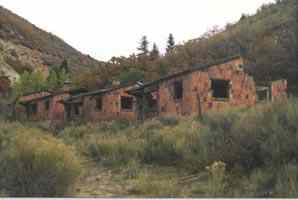
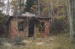
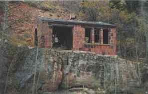
| NAME: National COUNTY: Carbon ROADS: 2WD Grid #: 9 CLIMATE: winter and summers as cool snow banks lasting into June. Aspen trees grew in our yard - T.L. Murphy BEST TIME TO VISIT: Anytime |
COMMENTS:
Notice the color of the material used to
build the buildings.(Update 9/99, Harold Frodge) Turn off US-6/191 onto
Consumers Rd. north of Price. At 9.1 mi., turn right past a corral. There
is one partial stone building on fenced property and a not-so-old shack
to the left. You can see the stone building coming down Consumers Rd. Go
down Consumers Rd. another 2.4 mi. The only sign of National is some foundations
on the left. At this point, the road splits. Take the right fork 0.4 mi.
to the site of Consumers. There are only a few stone foundations. Go back
ro the split and take the left fork 0.3 mi. to the site of Sweet. There
is no evidence of a town. There is a large stone foundation across the creek
which may be the remains of a railroad trestle. 2WD easy to the points mentioned
but trails get muddy beyond these points. REMAINS: Many original buildings. |
| National was a coal town that had its boom in the late twenties. All of the houses and buildings were constructed of the same red brick. Coal was mined right up until the depression when the town was hard hit and died. Originally, coal was discovered in 1908 but wasn't really exploited until the National Coal company came along in 1926. The town owes its name to the company. Today, there are many remnants of the town still left. |
|
|---|
|
|