BOW CITY
|
BOW CITY |
|
|
|
|
NAME: Bow City COUNTY: N/A ROADS: 4WD GRID: 2 CLIMATE: Mild summer,cold winter BEST TIME TO VISIT: Summer |
COMMENTS:
SW Corner of Alberta REMAINS: Nothing |
|
Located 12 miles south of the Trans-Canada Highway on Highway36 then about eight miles west along Secondary Road 539, Bow City was once a humming little coal-mining town. The district was opened for homesteading in 1907 and brought get-rich-quick promoters flocking to the area touting vast coal deposits. It was touted as the Pittsburg of the West. It appeared for a time that a genuine city would sprout on the plains but, unfortunately, the First World War came along, capital dried up and the much-ballyhooed project never materialized. Bow City received a small shot in the arm when strip mining began in 1932 then again during the Second World War when the Alberta government financed a new townsite on the south bank of the Bow River to house the miners who were keeping the coal flowing to fuel Canada’s considerable war effort. But after the war natural gas and fuel oil became the main heating fuels and coal was gradually phased out and the Bow City mines abandoned. H.B. Chenoweth I came across your site this evening, great to see someone is keeping the memory alive. Just a few comments or things to add to the Bow City page if you feel it is important. I uploaded a picture of the original sign on you website, the sign still welcomes people to Bow City today. The area was actually called Eyremore before the name was changed to Bow City, however I am not aware of the exact date. Behind the sign you can faintly make out the foundation of the old general store, next to that used to be a garage, I have found old oil cans and other parts in the field there in the past. The house in the background of the picture belonged to my Grandfather and is still in the family. I spent many months there in my childhood so I know the area well. My Grandfather worked in the coal mines and farmed the land in the area, he actually used to own or lease all of the land the old coal mines were situated upon. Unfortunately the last original building burned to the ground about 13 years ago in an accident. It was the garage where they fixed the mining equipment and the last time I was in there, many items from the mining days were still there, including the office with extensive records. Today there are some large slack piles and surface mine pits as the land was never reclaimed. The deep surface pits have been filled in with water and stocked with trout, a few anglers camp there each summer to fish the ponds. The underground mine is a short trip across the river, the only evidence of its existence is a small pile of dirt over the shaft in the middle of a field. In the middle of the prairie, one can make out the location of the original highway and dirt piled by the railway for tracks before the project was abandoned. There are still a handful of residents that live in the area, some of which have built houses on the old mining camp location along the river's edge. The original bridge built around 1912 was taken down a few years ago to make way for a larger one, it was not wide enough for 2 lanes and the deck was still surfaced with wood. There is also a nice small campground on the rivers edge with a outdoor cook facility, boat launch, and a ballpark. I actually have a very extensive book detailing the history of the area with many historical pictures, it was compiled by a local resident many years ago.
Hope this is some use to you. Thank You. Ryan Smith |
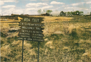 Bow City Courtesy Ryan Smith |
|
|