EL DORADO and
SHINGLE SPRINGS
|
EL DORADO and SHINGLE SPRINGS |
|
|
|
|
NAME:
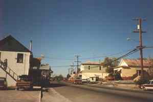
El Dorado and Shingle Springs COUNTY: El Dorado ROADS: 2WD GRID #(see map): 3 CLIMATE: Cool winter, warm summer BEST TIME TO VISIT: Anytime. |
COMMENTS:
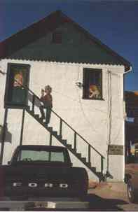
Just south of Placerville, Semi-ghost. REMAINS: Many original buildings. |
|
El Dorado and Shingle Springs were neighbors during the gold rush days. Shingle Springs received its name from its shingle mill and from its spring of water. El Dorado was first named Mud Springs from the muddy and soggy ground which surrounded its spring of water. Shingle Springs was never known as a gold camp as it had only a limited supply. El Dorado, on the other hand, provided miners with both placer and hard rock operations. Both were rich sources while they lasted but neither lasted very long. El Dorado is located on high 49, a short distance south of Placerville. The original Wells Fargo building is the principal historic site. Once called Mud Springs, El Dorado was founded as a way station at the foot of the Carson Pass emigrant route. During the 1850s it boomed as a mining camp. Buildings that remain from the gold days are the brick Wells Fargo office (now a restaurant and bar) and three other stone and brick structures. Submitted by Henry Chenoweth. Once a stopping place on the road from Sacramento to Placerville, it grew into a mining town when gold was discovered in 1850. The Wells Fargo Office and what was originally called the Shingle Springs House both date from the 1850s can still be seen. Submitted by Henry Chenoweth. |
|
|---|
|
|