HILL
|
HILL |
|
|
|
|
NAME: Hill COUNTY: US ROADS: 4WD GRID: 3 CLIMATE: snow in winter BEST TIME TO VISIT: summer is best, floods in spring |
COMMENTS:
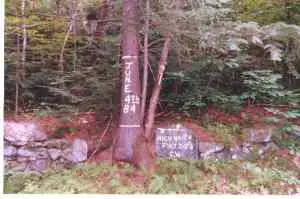
Of Rt 4 in Hill, NH next to Post Office
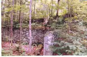
is a dirt road to old site of former Hill town location REMAINS: Some cellar holes, open fields. |
|
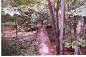
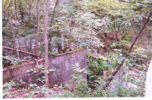
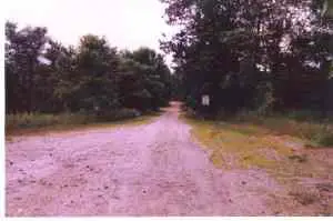
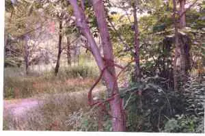
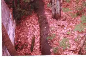
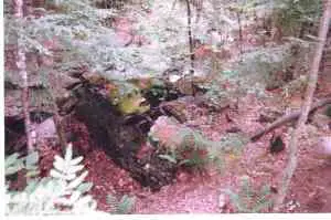
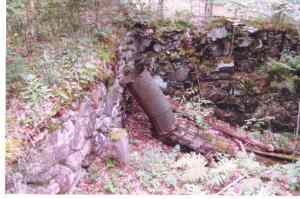
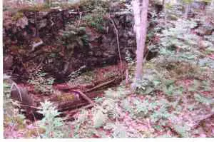
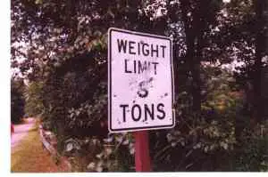
I used to live in Bristol, NH the next town over from Hill, NH. I was told that the old town site was constantly being flooded every spring, and, in fact, you can see dead branches some 30 feet high in the trees that were obviously not from the same tree. In the early 1900's the residents of Hill decided to move the town up on the bluff. They moved buildings and all. All that remains in a few cellar holes, a wroght iron railing that young have grown around and even one with the railing thru it. Also there's a lonely tree in the center which appears that it may have been the town square. Submitted by: Bruce Richardson Update:The information about the Post Office is misleading. There is a sign near the post office which gives a brief history of the town flooding and relocation. The area behind the post office is NEW Hill not OLD Hill. Also it says that it is located on Rt4. While you can get to Hill on Rt4, the post office is actually on Rt3a. To get to old hill, drive about 1 mile past the post office on Rt3a (going North, the post office is on the right). Take a right on Old Town Road(appropriately named). Drive past the cemetery on the left. The street will end at the entrance to the old town. Shop Rd. will be behind to the right. Park there and walk past the road block. Cross the foot bridge and your there. There are two major areas of the defunct town. The first "neighborhood" is on the immediate left, next to the river. Cut through the brush down to the edge of the cliff(a sharp drop of about 30 feet). There are a dozen or so foundations with a rusted sewer pipe running through them all, very cool. On the path above someone has placed a marker indicating the various high water marks. You could see how this seasonal flooding could have destroyed the town. At the bottom of this "road" is the other "neighborhood." This is the intersection which would have been the center of town. Turn left and you will cross a turn-of-century bridge. The state has posted weight limits for this bridge. Someone uses the sign for target practice. The road continues in this direction for several miles, we did not walk to the end. Keep your eyes open and you should find a on old, rusted bicycle. Turn right at the intersection and you should find crumbling sidewalks on either side. Creepy. Walk on the sidewalks and at you will see many of the old foundations and crumbling steps. There are also railings and barbwire fences that trees have grown around. The road continues in this direction for several miles, we did not follow it to the end. The sidewalks continue for quite some distance. There are small stone makers with letters on them. They look recent and may be part of some preservation effort. The foundations are covered by heavy brush in summer. May be easier to see during the fall. The fields and woods around the town are a wildlife preserve, this is posted everywhere. I don't know why they called it "Hill", it's in the middle of a valley! Garth Bruen Boston, MA UPDATE:It was incorporated in 1753 as New Chester by several men living in Chester, who bought 30,000 acres as speculation. During the 1830s, the townspeople learned that there were a least 100 communities in the country with the name "Chester", and they wanted to be different so they renamed the town Hill, after the then current governor, Isaac Hill. The Pemigewasset River, along side which the town was originally built, is a major tributary of the Merrimack River, which provided water and power for the many textile mills in southern New Hampshire, Massachusetts, and Connecticut. The Pemigewasset was prone to flooding because it had to carry off the melting snow from the White Mountains. In order to control this situation, the Army Corps of Engineers proposed in 1937 to build a flood control dam a few miles south of the village. The federal government offered to buy the individual properties, but many of the townspeople wanted to maintain their identity instead of having to move to other communities, and voted to relocate the town when the government also offered to pay to move houses to the new site. Fourteen buildings were moved to higher ground, using railroad winches and horses. The new village was actually established in 1941. It is my understanding that Old Hill is now closed to vehicular traffic. -Clifford Otto |
|
|
|