BUENA VISTA
|
BUENA VISTA |
|
|
|
|
NAME: Buena
Vista COUNTY: Mineral ROADS: 4WD GRID: 7 CLIMATE: Pleasant summers, heavy snow and impassible in winter BEST TIME TO VISIT: Summer, autumn |
COMMENTS:
Roads may or not be navigable
with two wheel drive. Best to have a 4x4. REMAINS: Scattered mining ruins, a few cabins, 10-stamp mill. |
|
Buena Vista was a collection of several townsites and mines at the north end of the White Mountains, south of Montgomery Pass. The region was periodically active before 1905 as part of the Montgomery Mining District. After 1905 the district was called the Oneota Mining District. In the year 1905 a mild rush was on to Buena Vista. Mines straddled the backbone of the White Mountains north of Boundary Peak (Nevada’s highest point and barely inside the state) and south of the former Carson & Colorado Railroad. Dwellings and businesses seemed to collect wherever mines were found and several minor “suburbs” formed in the primary Buena Vista district with no particular pattern or formation of a main Buena Vista townsite. Some newspaper accounts give confusing details as to Buena Vista, specifying particulars of newsworthy events as happening high up in the Tip Top Mine area, or down on the railroad near the tunnel (W of Montgomery Pass). Some of the mines were (and are) found at altitudes approaching 11,000 feet, some are found down near the railroad grade at an altitude below 7,000 feet. As the name implies, Buena Vista = “good view,” and that is the case on the crest from Tip Top (Sugarloaf Peak) to Mustang Mesa. A 360º view is found at those points, with vistas ranging to the west to the Sierra Nevada (from the Cottonwood Canyon country to the south to north of Bridgeport to the north), to the north toward Hawthorne, to the east-northeast to the Toiyabie and Toquima Ranges, and southeast into the Lida area. The region was part of Esmeralda County
until 1911, when Mineral County The region quieted down substantially
by 1907 and most post offices Townsites and Post Offices include: · Buena Vista (PO active December
14, 1905 to April 24, 1911) Today ruins can be found by taking a dirt road south from US6 at Montgomery Pass (accessed by driving around the back of the Montgomery Lodge Casino). Beginning at Sugarloaf Peak, extensive mine ruins are found. The road continues up to Mustang Mesa, where a locked gate blocks further access. Mines are found on both sides of the main ridgeline. In side canyons, several structures can be found. A sleigh from the period is found near Tip Top Mines. A 10-stamp mill can be found in a side canyon near Gold Hitt. The Forest Service has tentative plans to remove the mill, but a location to put it has not been settled: put it at the Central Nevada Historical Society museum at Tonopah? Or take it to the Laws Museum near Bishop, California? The mill is located in Nevada, so the Tonopah site is favored, but since it is located on Inyo National Forest land, which is headquartered in California, the Laws site has much favor. Some notable events as told in the Inyo Register newspaper (Bishop, CA) through 1909: · September 28, 1905 Inyo Register
- First published newspaper account of Buena Vista. ___________________ |
 Map of Buena Vista 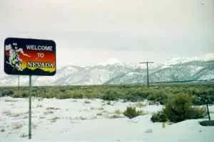 View east toward the Buena Vista area of the White Mountains from the California / Nevada state line on highway US6. Sugarloaf is the prominent peak in the middle background. January 25, 1998. Courtesy David A. Wright 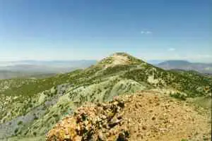 Sugarloaf Peak and the Tip Top Mine area. View north. July 3, 1995. Courtesy David A. Wright  Stone claim markers. Near Mustang Mesa at an elevation just under 10,000 feet. View northeast into the interior of Nevada. July 3, 1995. Courtesy David A. Wright 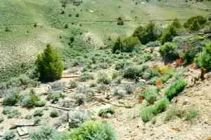 Lumber remains near stamp mill. July 3, 1995. Courtesy David A. Wright  An old sled used to pull items through the abundant snows of winter. July 3, 1995. Courtesy David A. Wright 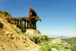 10-stamp mill in canyon on the east side of Sugarloaf Peak. July 3, 1995. Courtesy David A. Wright 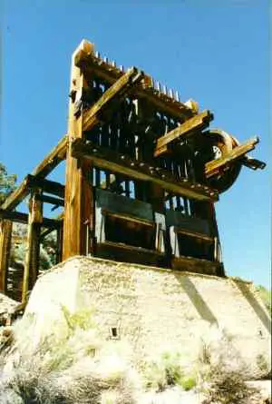 10-stamp mill. July 3, 1995. Courtesy David A. Wright 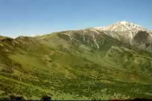 View from Mustang Mesa, nearly 10,000 feet elevation, into Indian Queen Canyon, an older mining area that predated Buena Vista by two decades. The Indian Queen area was extensivley worked during the period that Buena Vista came alive. View is south toward Mount Montgomery (in California) and Boundary Peak, Nevada's highest point. July 3, 1995. Courtesy David A. Wright 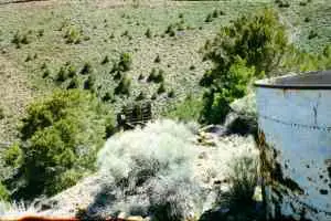 Water tank and 10-stamp mill. July 3, 1995. Courtesy David A. Wright 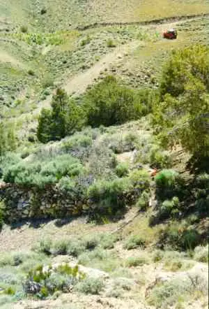 Stone retaining wall once held a fairly large structure near the stamp mill. July 3, 1995. Courtesy David A. Wright 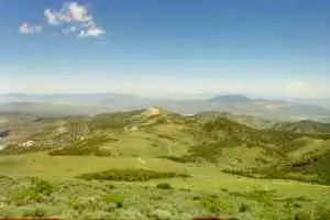 View from near Mustang Mesa northward over Sugarloaf Peak, itself over 9,000 feet elevation. July 3, 1998. Courtesy David A. Wright |
|
|