HOW TO READ
TOPOGRAPHICAL MAPS
By
Boris Vasilev M.S.
Professor of Geography
Paradise Valley Community College
Phoenix Arizona
|
HOW TO READ TOPOGRAPHICAL MAPS By Boris Vasilev M.S. Professor of Geography Paradise Valley Community College Phoenix Arizona |
|||
|
|
|
Knowing how to read a USGS topographical map is essential to successfully finding a ghost town. USGS topographical maps are useful because they show the terrain and lay of the land as well as feature like roads, structures and mines. As you read this, it would be helpful if you also had your own topographical map to refer to. The first thing to notice on a topographical map is the title. It is found in the top right hand corner of the map: 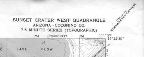 The title for this particular map is, "Sunset Crater West Quadrangle." At the corner, but in smaller print is another title called Strawberry Cheater. That is the title of the next topographical map to the northeast of this one. You will find similar titles on all the corners of a topographical map as well as halfway between the corners. Use that information to find the other maps that you may need.
Latitude and longitude is the most common grid system used for navigation. It will allow you to pinpoint your location with a high degree of accuracy. Latitude is angular distance measured north and south of the Equator. The Equator is 0 degrees. As you go north of the equator the, latitude increases all the way up to 90 degrees at the north pole. If you go south of the equator, the latitude increases all the way up to 90 degrees at the south pole. In the northern hemisphere the latitude is always given in degrees north and in the southern hemisphere it is given in degrees south. Longitude works the same way. It is angular distance measured east and west of the Prime Meridian. The prime meridian is 0 degrees longitude. As you go east from the prime meridian, the longitude increases to 180 degrees. As you go west from the prime meridian longitude increases to 180 degrees. The 180 degree meridian is also known as the international date line. In the eastern hemisphere the longitude is given in degrees east and in the western hemisphere it is given in degrees west.
At the equator, one degree of latitude or longitude represents approximately 70 statute miles. At higher latitudes the distance of one degree of longitude decreases. Latitude stays the same because they are always equally spaces apart. If you look on a globe you will see this to be the case. On the other hand , if you look on a globe you will notice that the lines of longitude get closer together as they approach the north and south poles. Degrees are not accurate enough to find a precise location. At best, one degree of latitude and longitude would define a 70 square mile area. To over come this problem, 1 degree is divided into 60'(minutes). So if 1 degree equals 70 miles and one degree can be divided into 60' then 1' equals 1.2 miles. Dividing 1 degree into 60' allows one to calculate their position with much better accuracy. In some instances even more accuracy is needed. To do this we can divide 1' into 60"(seconds). If 1' equals 1.2 miles and we can divide it into 60", then 1" equals 0.02 miles. It it is worth taking a few seconds to memorize the following numbers. It will help you to use latitude and longitude more effectively: 1' = 1.2 miles 1" = .02 miles If you look at the picture above you will notice the latitude and longitude in the lower right hand corner of the map. You would read it as 35 degrees 15 minutes north latitude and 111 degrees 30 minutes west longitude. Below the title you will notice the words 7.5 minute map. This means that the map covers an area of approximately 7.5 minutes of latitude and longitude. UTM Stands for Universal Transverse Mercator. It is another grid system that can be used to find your position. It is most commonly used in the military and for research as well as survey purposes. The UTM system divides the surface of the earth up into a grid. Each grid is identified by a number across the top called the zone number and a letter down the right hand side called the zone designator. For example, Phoenix Arizona is in UTM grid 12 S.
Every spot within a zone can be defined
by a coordinate system that uses meters.
Map scale represents the relationship between distance on the map and the corresponding distance on the ground. The scale on the topo map is found at the bottom center of the map. 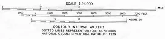 Scale is represented in two different ways on a topographical map. The first is a ratio scale. The ratio scale on this map is 1:24,000. What it means is that one inch on the map represents 24,00 inches on the ground. Below the ratio scale is a graphic scale representing distance in miles, feet and meters. The graphic scale can be used to make fast estimates of distances on the map. The space between the 0 and the 1 mile mark on the scale is the distance you must go on the map to travel one mile. One of the advantages to using a topographical map is that it shows the three dimensional lay of the land. It does this by using contour lines. A contour line is a line that connects points of equal elevation. On the topo map they appear as the brown lines. 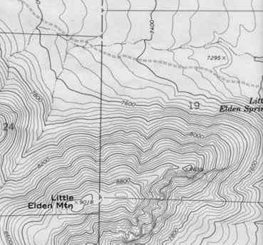 The contour line traces the outline of the terrain at evenly spaced elevations. These are determined by the contour interval. The contour interval is found below the map scale. For this map, the contour interval is 20 feet. That means that every time you go up to another brown line the elevation increases by 20 feet and every time you go down a brown line the elevation decreases by 20 feet. In the lower left hand corner of the map there is a mountain. Notice how the contour lines define the shape of the mountain. The lines are closer together at the top of the mountain where it is steeper. The spacing between the lines decreases as the slope of the mountain decreases.
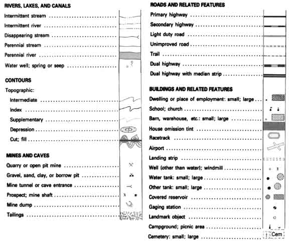
The Township and Range system, sometimes called the Public Lands Survey System, was developed to help parcel out western lands as the country expanded. The system takes many western states and divides them up using a base line and a principal meridian: 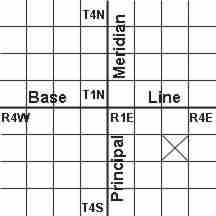 As you go to the east or west of the principal meridian, the range increases in that direction. If you go north or south of the base line, the township increases. This system divides the land up into townships and ranges that are 36 square miles each. In the diagram above, the square with the X in it would be defined as township 2 south (T.2S), range 3 east (R.3E). Each township and range is then subdivided into 36 sections. Each section is one mile square. Individual sections are then subdivided into half sections and quarter sections and so on. On a topo map, you will notice a grid with red lines and text crisscrossing the map. The lines represent the boarders of the various sections in the township and range of that area. In the map below you can see sections 23, 24, 26 and 25 of T.22N, R.7E. 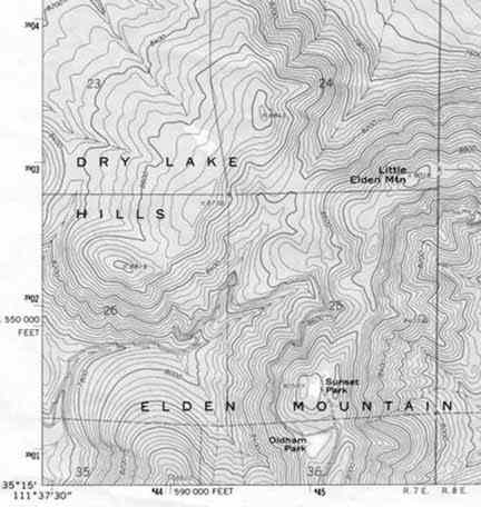 There are many other symbols on USGS topographical maps. Here are some of the most common:
|
|
BACK | HOME |
 The
next thing that you should notice on a topographical map are
the numbers running all around the outside of the map. These
numbers represent two grid systems that can be used to find your
exact location. The first is called latitude and longitude. The
exact latitude and longitude is given at each corner of that
map and at equally spaced intervals between the corners. The
second is called UTM's. These are the smaller bold numbers that
run along the border of the map.
The
next thing that you should notice on a topographical map are
the numbers running all around the outside of the map. These
numbers represent two grid systems that can be used to find your
exact location. The first is called latitude and longitude. The
exact latitude and longitude is given at each corner of that
map and at equally spaced intervals between the corners. The
second is called UTM's. These are the smaller bold numbers that
run along the border of the map.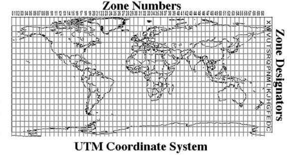
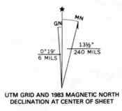 At the
lower left hand corner of topographical maps there is a symbol
called the magnetic declination. The symbol is used in conjunction
with a compass for navigational purposes. The center line with
the star above represents the direction of true geographic north.
The line coming of to the right represents the direction of magnetic
north, When using a compass, the needle always points to magnetic
north. The symbol tells you that for the area the map covers,
the magnetic compass needle will always point 13.5 degrees to
the east of true geographic north. To the left of the true north
line is the grid north line. This tells you how much the UTM
grid and zone lines are offset from true north.
At the
lower left hand corner of topographical maps there is a symbol
called the magnetic declination. The symbol is used in conjunction
with a compass for navigational purposes. The center line with
the star above represents the direction of true geographic north.
The line coming of to the right represents the direction of magnetic
north, When using a compass, the needle always points to magnetic
north. The symbol tells you that for the area the map covers,
the magnetic compass needle will always point 13.5 degrees to
the east of true geographic north. To the left of the true north
line is the grid north line. This tells you how much the UTM
grid and zone lines are offset from true north.